
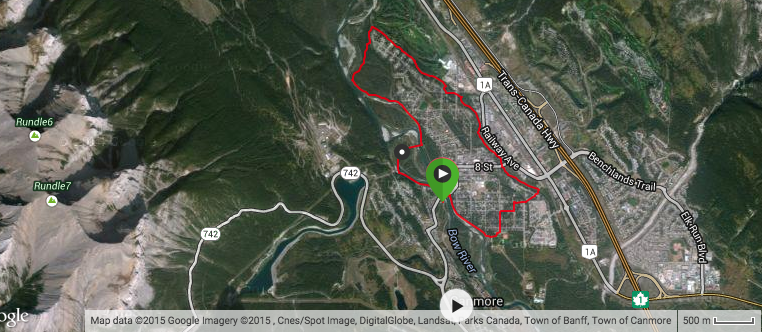
And so to the third of my trail running route posts – the Bow River Loop.
This is probably the most “urban” of the runs that I do in that it takes place largely within the town, though there’s nothing particularly urban about it. True, there are sections where you actually run on pavement and within the vicinity of cars (quelle horreur!). But for much of the time you’re running along the banks of the majestic Bow River with spectacular views of Mount Lawrence Grassi, Mount Rundle, Lady MacDonald, Grotto and Cascade Mountains and the Fairholme Range. And when there are no views to savour, it’s only because your whizzing down fast, tree-shrouded, root and rut strewn trails along Policeman’s Creek and around Larch Island.
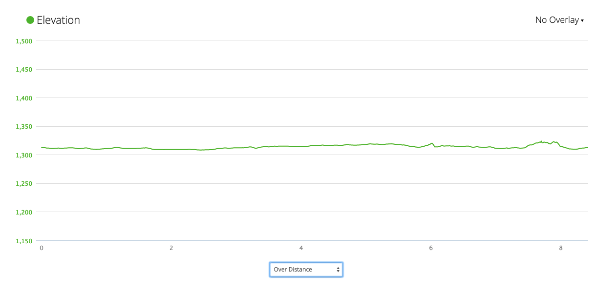
The Bow River Loop is just over 8km long with very little elevation (a whopping 22 metres):
There’s a side option for climbing should you feel so inclined which is mentioned below. Otherwise, this is a great route for simply taking it easy, or else for speed work and interval training which I tend to find is best done on the flat.
The run starts and finishes at the road bridge over the Bow River, near the centre of town. If you pass over the bridge from downtown there’s a parking area on the left near the boat launch. From the parking, head upstream and across the road bridge and turn right down the path that runs along the left bank of the Bow River. The views from the bridge and the river bank are awesome:


After one kilometre you’ll arrive at Elk Island View. Follow the path to the left that leads you through a bike skills area and into Millennium Park. Head through the park to the car parking area at the top of 5th Avenue. Run down 5th Avenue until you reach 5th Street which is just on the corner of Centennial Park, another of Canmore’s great parks (it has a running track in case of need). Turn right into 5th Street and proceed along there, take the bridge across Spring Creek and head into the Spring Creek condo development.
Follow the footpath through the condo development and in the direction of the far side of the valley:

Take the pedestrian bridge over Policeman’s Creek and then hang an immediate left and follow the trail alongside the creek and which turns, after a short distance, into this bouncy boardwalk:

The boardwalk will bring you to Main Street. Head straight across, keeping the bald chap below to your right, and continue along the trail than runs parallel to the creek:

From here it’s all relatively straightforward in that you stay on that trail alongside Policeman’s Creek following the blue/white signage:
 After a few hundred metres, cross over 8th Street, pick up the trail again and after around 3.6km (from the start) you’ll come out of the trees at this intersection:

Go across the two crossings shown here and then head left, along 17th Street. After a 100 metres or so there’s a trail off to the right, marked with the blue/white signage. Follow the trail which offers more beautifully quiet, shaded and fast trail:
 At the 5km mark you’ll reach this intersection:
 Take the trail to the left until you see this sign for the Larch Island Hiking Trail:

Shoot down there and enjoy 1.2km of narrow, undulating, rooty, single track through trees and densely packed brush where it seems impossible not to pick up speed. The trail will pop you out again onto the blue/white signed trail which eventually joins up with the Bow River (and more amazing views):

Follow the trail until you reach the right turn that will take you to and across the Engine Bridge (shown above). Continue along the trail, through the trees and across the pedestrian bridge by the Trans Alta electricity plant. If by this stage you feel the need for some altitude you can head up this staircase, on your right:

From the top you can follow trails to Canmore Nordic Centre or up to Rundle Channel from where you can access the Powerline and Highline Trails, Grassi Lakes and more. Otherwise, continue along the banks of the Bow River, taking in the views of Lady MacDonald (left) and Grotto Mountain (right)…

..while also remembering to check out the awesome scene behind you:

After 200 metres the trail passes under the road bridge and brings you back to the car park where you began. If 8km wasn’t enough, you can continue along the trail (below) and the banks of the Bow River as far as Cairns Landing from where you can head up to the Three Sisters and the far end of the Highline.

Alternatively, you can beat a hasty retreat to any one of several great coffee shops in town and reward yourself with a latte and muffin.
I’ll be back again soon with some reflections on the challenges I am currently facing in planning the training for my next ultra.
Until then, happy trails.
