After a relatively early start, this year’s racing season has been an undulating affair and not just in terms of the topography. It began with the Torgon Trail in May, intended as a gentle start the season, followed in June by the Scenic Trail, which lived up to its name. Two weeks later, it was off to Chamonix for the Mont Blanc Marathon. Between them, there were some highs, a courageous comeback, a truly spectacular low, and some important lessons learned. Continue reading →
It seems I owe a lot to the Seven Summits trail race or “Trail des Dents du Midi”. Not only was it an awesome if gruelling experience which I may or may not put myself through again. It also introduced the Canmore Runner family to the sheer beauty of the Val d’Illiez and the fabulous postcard perfect village of Champery in the Valais, Switzerland. In fact, we liked Champery and the surrounding area so much that, to paraphrase Victor Kiam, we bought the place. Okay, we maybe didn’t buy it so much as keep coming back and rent a small apartment in town. Continue reading →
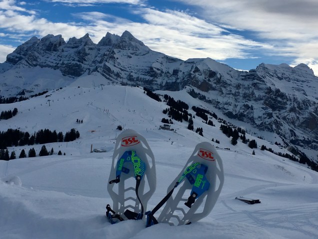
Dents du Midi and running snowshoes. A lot of fun but not ideal preparation for races that don’t allow snowshoes. Photo: Canmore Runner
Inspired by Ms. Canmore Runner’s dedicated preparation for some quality, sub-zero suffering/heroism on the misery sticks at this year’s Trans Jura and Birkebeiner Nordic ski races, I decided to get my own 2018 race face on. First up, the much less daunting 21km Trail Blanc Diablerets at the beginning of March. Continue reading →
Fitzy, at the Plain of Six Glaciers, Lake Louise Photo: Canmore Runner
You could be forgiven for thinking that not much happened for Canmore Runner in 2017, beyond some spectacular runs earlier in the year in Annecy and Courmayeur with Canmore running sensation Fitzy. But contrary to the saying, “if it isn’t on [insert social media here], it didn’t happen”, just because I didn’t find the time to blog about it, doesn’t mean it didn’t happen. And for sure, 2017 saw some beautiful runs in and around Geneva, a quick trip back to Canmore, and one cracking ultra. So, in no particular order, here are some things that I didn’t quite manage to blog about in 2017… Continue reading →
The sunny side of the Mont Blanc massif – Photo: Canmore Runner
Lured by the prospect of sensational weather, amazing scenery and trails, friendly locals and delicious post-run food, Fitzy and I headed off for a day of trail running around the stunning Italian mountain town of Courmayeur on, as some refer to it, “the sunny side of Mont Blanc”.
Located in the Aosta Valley in north-west Italy, around a 90 minute drive from Geneva via the Mont Blanc Tunnel, it’s no surprise that Courmayeur, like it’s French neighbour to the north, Chamonix, is a trail running paradise. It features in the legendary 170km Ultra Trail du Mont Blanc (UTMB) and hosts the start of the UTMB’s “little sister”, the 101km CCC, or Courmayeur-Champex-Chamonix, which, according to the organizers sets off in “an atmosphere that only Italians can provide, a rare emotional moment to the music of Vangelis”. Golly. It also boasts it’s own 105km Gran Trail race, not to mention the 330km Tor des Geants among others. It even has a Canmore Trail Culture equivalent in the Courmayeur Trailers.
Plan A for the day was to run some run-able parts of the Val Ferret, a truly stunning valley that heads north-eastwards along the bottom of the Mont Blanc massif, with stunning views of the Grandes Jorasses.
Looking towards the Grandes Jorasses in the Val Ferret Photo: Canmore Runner
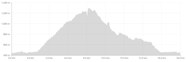
However, the closure of the Val Ferret due to the extreme avalanche risk put paid to that and so we headed a short distance past Courmayeur to the village of Palleuseiux. Our plan B was to pick a up the number 1 hiking trail from Palleusieux back up the Aosta valley towards Dolonne and Courmayeur along the banks of the Dora Baltea river. Again, the avalanche risk scuppered our plan but undeterred, and after a quick map consultation, we continued down the valley a few minutes to the small spa town of Pre Saint Didier. From here, plan C was to pick up the number 6 hiking trail, and proceed up and into the, hopefully sun drenched and relatively snow free, Thuile Valley and basically take it from there. And that’s what we did, and wow, as Plan Cs go it was superb. It might have been a relatively short 8km out-and-back-ish but what it lacked in distance it more than made up for in ascent (1,416m), challenging trails and incredible views.
On Strava, it all looked like this:
We began at the rather luxurious looking QC Terme Pre Saint Didier thermal baths from where you can pick up a trail that leads you into the bottom of a very steep-sided gorge before heading up the side of the gorge along a series of relatively steep but mostly run-able switchbacks:
Photo: Canmore Runner
..with some beautiful views…
Photo: Canmore RunnerPhoto: Canmore Runner
After around a kilometer or so, the trail flattens out and takes you to the the Parco Avventura Mont Blanc. Follow the trail to the car park at the far end of which you will see a sign for the number 6 hiking trail. Follow the number 6 which continues to wind it’s way up (emphasis on up) along the side of the valley:
Photo: Canmore Runner
At around the 2.6km mark, we caught a first glimpse of the valley opening up and got a sense that good things weren’t all that far off:
Looking towards La Thuile – Photo: Canmore Runner
And sure enough, it wasn’t much longer before we reached some abandoned buildings…
Photo: Fitzy
from which we were presented with views like this:
Photo: Canmore Runner
At this point, the trail splits and you can either continue to follow the number 6 and now number 3 hiking trails along the valley towards the village of Elevaz or, as we did, follow the marked trail that continues to zig zag up the side the valley. After around 1km we completely lost the trail under a foot of snow and resorted to a combination of bush-wacking and post-holing, albeit with a great backdrop:
Photo: Canmore Runner
This continued for the next 700m, more or less straight up towards Monte de la Nonna in the hope that at some point we would be able to see back along the Aosta Valley towards Mont Blanc. That point soon arrived and we were not disappointed. First there was Monte Corme to the east:
Photo: Canmore Runner
And then Mont Blanc in all its splendour:
Mont Blanc – Photo: Canmore Runner
By this stage, overwhelming though the views were, we were also beginning to fixate on the delicious food aspect of this Italian road trip and promptly retraced ours steps to the trailhead:
Photo: Fitzy
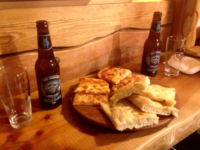
…drove back to Courmayeur and got on with the serious business of ordering foccacia e birra in very poor Italian:
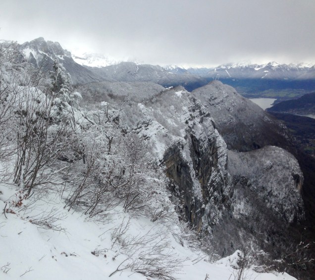
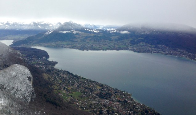
Annecy, France. A mere 25 minute drive from Geneva, the “Venice of the Alps“, home to those gear gurus Salomon, and, it turns out, some spectacular trails.
Joined – all the way from Canmore – by Fitzy, my much missed running companion and leader of Canmore Trail Culture, our objective for the day was an 18km loop with, according to Strava, 2370m of climbing (not sure that’s right) up and over the summit of Mont Baron, on the east side of the beautiful (even on a grey day) Lac d’Annecy:
Monts Baron and Veyrier. Photo: Canmore Runner
You can shorten this run by a good 5km if, unlike us, you choose to begin at or near the trailhead, rather than parking in town and running along the lake front. It seemed like a good idea when we arrived but a terrible idea two and a half hours later as I laboured back along the lake front. On Strava, it all looked like this:
The trailhead is located just off the D909 which is the road that follows the east side of the lake heading from Annecy towards Veyrier-du-Lac. It’s reasonably well signposted:
Photo; Canmore Runner
..and the trailhead is quite obvious:
Photo: Canmore Runner
But if you are in any doubt, just look for this wonderful sight: Ecrin des Gourmandises Boulanger, right smack dab at the trailhead, with the most amazingly dense and delicious pain au chocolat aux amandes. This was surely shaping up to be a good day.
Photo: Canmore Runner
A word to the wise, however. Tempting though it will be, don’t stuff your face because from here it’s more or less uphill for the next 5.4km and the start is steep and rocky:
Fitzy, showing little sign of jet lag – Photo: Canmore Runner
And it more or less continues like that all the way to the Plateau du Mont Baron. The route is relatively straightforward – just keep following the signs for Mont Baron and Mont Veyrier, of which there were quite a few:
Photo: Fitzy
The climb is a beautiful twisting affair, that takes you around the backside of the mountain with a few dips long the way to give you the chance to recover.
If we’d studied the map a little more carefully, we would probably have taken the steeper trail that heads off to the Col des Sauts and Mont Veyrier around 2.5km from the trailhead and from where you can run along a balcony to Mont Baron. But alas, we didn’t study the map carefully and headed to Mont Baron via the Creux du Loup. But I wouldn’t say we were disappointed. It was something of a winter wonderland:
Photo: Fitzy
You’re in the trees for most of the climb to the Plateau du Baron, which would probably be quite welcome in the heat of the summer. But you just know that the trees will give way at some point and spectacular things await and so they do. A mere 300m further on from the Plateau and the trail brings you to this:
From here, you keep heading along the balcony and the trail drops down a bit:
Photo: Canmore Runner
…before eventually delivering you in around 500m to the Ancien Telepherique:
Photo: Canmore Runner
From here, we took the trail down towards Veyrier-du-Lac which involves navigating a slightly steep and sketchy staircase, albeit with a great view:
Photo: Canmore Runner
At the Balcon des Contrabandiers, we continued to follow the signs for Veyrier-du-Lac which took us down a wonderful free flowing singletrack with lots of hairpins and chance to really open up the legs.
Photo: Canmore RunnerPhoto: Fitzy
Rather than heading into Veyrier-du-Lac, we followed the trail that was signposted for the Col de Sauts and Mont Veyrier but later dropped off this and onto the trail leading to Chavoire and Talabar. This eventually put us back on the trail we’d started out on from the trailhead which, of course, led us happily back down to the boulangerie.