
Thank you Yamnuska. It was epic. It’s only about a 10km loop but you pack of lot into those 10km: a challenging but largely run-able climb that gains around 994m in elevation; easy-going forest trails that deliver you to the exposed and more technical backside of the mountain before reaching the summit with its breathtaking panoramic views. From there, a scorching, scree-skiing descent leads you around the frontside of the mountain and back into the trees before returning to the trailhead. It’s a blast.
It’s also not necessarily for the faint hearted. At around 300m from the summit you have to traverse a narrow 30m-long ledge. There is a chain to cling onto but if you’re not a fan of heights this might be a good place to turn around. But don’t worry, you’ll have still benefitted from some spectacular views and run some awesome trails.
If you’ve driven along the Trans-Canada Highway between Canmore and Calgary you will almost certainly have seen Mount Yamnuska. It’s hard to miss with an elevation of 2,240m and its striking, sheer 500 foot, limestone face:

Indeed, Yamnuska is the Stoney Nakoda word for “wall of stone”. In 1961, Yamnuska was officially renamed Mount John Laurie at the request of the Stoney Nakoda to honour Laurie, an educator and political activist who served as secretary of the Indian Association of Alberta from 1944-1956. Nonetheless, Yamnuska seems to have stuck.
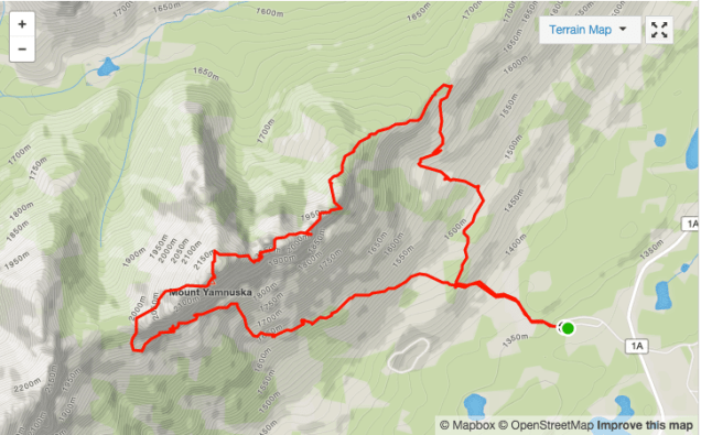
The trailhead is located at the far end of the Yamnuska car park on the north side of Highway 1A, about 20 minutes east of Canmore along the Trans-Canada Highway. From here begins a 10km loop that looks like this on Strava:

The trail is easy to find and follow. It begins in the trees, slowly working its way upwards and offering occasional glimpses of the summit:

There are some steep sections in places, but nothing too arduous. After around only 800m you’ll reach a fork in the trail with a sign telling you that both left and right go to Yamnuska. Take the right fork, unless that is you fancy climbing (as in ropes and harness and some technical know-how) straight up that imposing rock face to the summit.

The trail continues its gradual climb upwards and remains generally easy to follow. There’s one spot where you need to keep your wits about you and not get distracted by the view…


…and miss an all important left turn. Fortunately, someone had the foresight to place this on the trail:

The trail continues up and the views continue to impress as the day’s objective becomes nearer:


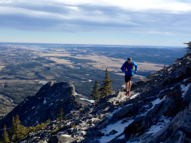
After around 2.7km you emerge from the trees and begin the scramble around the backside of Yamnuska:

The trail remains relatively easy to follow and there are painted blue squares at regular intervals to help keep you on track as you continue to climb – and run – to the summit:

As I mentioned, there’s one spot where you need to negotiate a narrow, 30m-long ledge (thankfully with a chain to hang onto). I found this be less daunting in reality than it had been in my mind prior to the run. In any event, it does require care and attention:

From here, the trail drops down before beginning the final approach to the summit:

The views from the summit are superb:


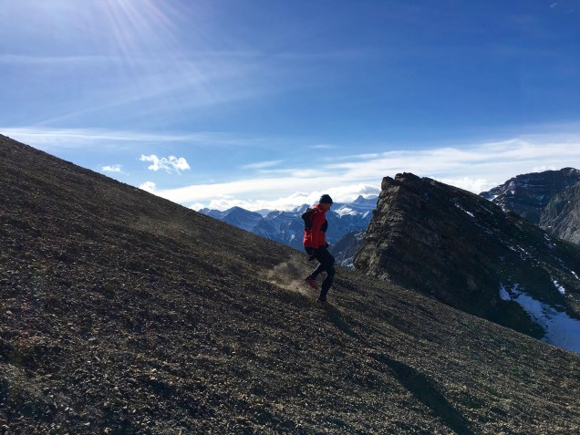
And then the fun really kicks into gear. From the summit, you take the trail heading west that descends along the ridge:

This soon veers away from the ridge and into the scree where you’ve just got to lean back, let go and enjoy the ride – not least because there’s more of this to come:

At around the 6km mark, the trail continues down but begins to turn back in the direction of the summit and eventually delivers you at the bottom of that 500 foot sheer face. From here, you continue to follow the trail through the scree and along the bottom of the rock face:

At the 7km mark you take a sharp right away from the rock face and head straight down a relatively discernible trail through the scree that swings left at the bottom:

True, it may look a little intimidating but it really is a lot of fun:

As mentioned, the trail swings to the left at the bottom and takes you back into the trees along some reasonably technical – rocky, root strewn and, on the day, very muddy and icy – single track:


At around 8.9km you’ll find yourself back at the fork you were at previously from where you retrace your steps back to the trailhead. Then it’s just a question of a quick change and figuring out where to go for coffee.

Thanks to Mike Fitzpatrick, Kimberley Al and Peter Salfner for their excellent company on the day.

2 thoughts on “Yamnuska Loop”